People have been bugging me for a picture, so........

I figured it was time to blog a bit about what I ACTUALLY do, not just the places I go and what I see. Sometimes it is hard work and other times.....not so much. Flying is relatively easy until something goes wrong or the weather goes to shit.

This is where it all happens. Pretty exciting. A couple hundred thousand dollars worth of instruments to watch and a plethora of buttons and switches. In the middle, at the bottom, is the power quadrant. Located here is a parking brake, 2 power levers to control how much power we need the engines to put out and 2 levers to manipulate the blade angle of the propellers.
Aircraft cockpits are designed to be pilot-friendly. Certain things are designed to reduce the chance of error. The landing gear up and down lever is shaped like a wheel. I'll let you have a minute to figure that one out. The flap lever is shaped like an ?????? Aircraft FLAP!!! Engine instruments have colour markings on them. Green is good. Red is bad.
The flap lever is on the quadrant to select different flap settings for take-off and landing. In the middle of the dash board are the engine instruments. To the right of the engine instruments is the gear lever.
Each pilot has the same instruments and controls. The 2 yokes, or control columns as we call them, are used to actually fly the plane. They are connected to each other but run off separate cable systems in case either side fails (ie. a cable breaks or jams). In front of each pilot is an altimeter (altitude above sea level), a Horizontal Situation Indicator (HSI-a fancy compass), an Airspeed Indicator, an ADF (Automatic Direction Finder-navigation tool), a TCAS (Traffic Collision Avoidance Sytem-displays on the instrument and orally tells us of possible collision threats) and an Artificial Horizon (to keep the brown side down and the blue side up. If this is opposite, you are inverted....not good with people on board......or. in this plane. Period.)
Back to the TCAS, if there is an airplane getting too close, we hear, "TRAFFIC" as an oral warning in the cockpit. If the aircraft continues to be a threat the system will say, "TRAFFIC," louder. If no action is taken and there is an imminent threat, the airplane will figure out the best course of action for you and tell you to "CLIMB" or "DESCEND". On the TCAS gauge it will depict how fast you must descend or climb to get out of danger. If the other aircraft near you is TCAS equipped, the two TCAS sytems will communicate and give each pilot the best course of action to take to get out of each others way. What I find a bit wierd is how the tone of the TCAS voice, shouting warning changes if corrective action is not taken quick enough, changes. The guy almost seems to get mad if we don't do what he asks of us. You would have to hear it to get the gist of it.
Anyways, I got a bit sidetracked for a sec there. At the top of the dash we have what we call the glareshield. Among other things is the FGC (Flight Guidance Computer). The buttons on the FGC allow us to tell the airplane how to navigate. The AutoPilot will fly what we tell the FGC to do....so if you tell the FGC to fly into a mountain it will do exactly what you told it to do. We are very careful how this is used and every action is confirmed by the other pilot for safety.

This is an FMS (Flight Management System). All of our company's preferred routes are stored in here. Once we select where we are going the GPS feeds its information to the FMS and the FGC flies it. Confused? It is actually easier than it sounds. Our routes consist of latitude, longitude and waypoints and are stored in a database. When we were told by Air Traffic Control to go PPOS (Present Position) direct TO REZIN (REZIN is a lat and long spot in space) we started a track of 323 degrees to get there. The time was 1919 Greenwich time (that's all we use). Some time went by before I took this picture, but now we are 156 Nautical miles from REZIN and will arrive in 46 minutes at a time of 2025. Once we reach REZIN we will turn to 327 degrees for 39 miles to our next NX waypoint. YUY is actually our destination today - Rouyn Noranda in Northern Quebec near the Ontario border. We will arrive there at 2039. An ADC (Air Data Computer) continually updates all of these times and distances as we speed up or slow down. Below this navigation info is "nice to know" info. The XTK is the crosstrack indicator. The AutoPilot is 0.11 nautical miles to the right of the track it is supposed to be on. We have a headwind of 36 knots and the wind at this altitude is from the direction 267 (WEST) at 47 knots. Over on the right, it displays our GS (Groundspeed), or, our speed travelling over the ground. 202 knots.....230+ miles an hour.

One of the fancy things we can do is put the FMS info up in a map mode to show where we are going, like lines on a map. We can also superimpose our weather radar on the same screen to see if our planned route will take us through any bad weather. Today it will. With some careful plotting we are able to find a way through this line of thunderstorms. Fortunately, the line of thunderstorms was quite visible out the window and I was able to get a picture of our route through the hole.

I wish dodging thundertorms was always this easy. REZIN is just on the other side of the line of thunderstorms, directly though that hole on the right.

This is the first aircraft I have ever flown with Terrain Awareness and Warning System (TAWS). It is best put to use flying in mountainous terrain like BC and doesn't really get used very often out here. It's too damn flat. It depicts what is in front of the aircraft, terrain wise, even when in cloud. So it will very accurately display a whole mountain valley as you fly down into it. I have spoken with a few pilots that have used it and they say it is unbelievable and very nice to have going into to somewhere like Castlegar on a dark and stormy night.

The TAWS system has many variables to change but has three main displays. This is the picture you would see behind the plane. Not much in front of us today. It will show some larger lakes and depicts the St. Lawrence River very well. As we used the MAP mode before, we can superimpose the map on this display as well to see if our planned route will take us near higher terrrain.

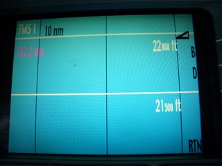
This the horizontal display. We are at our cruising altitude of 22 000 feet. If there were any mountains above 21 000 feet they would show up. If they were over 22 000 feet they would be red above the 22 000 foot line.
That's all I know so have fun piloting. Now you can use some of the pilot lingo in case you ever get stuck between some pilots and some hangar talk. Jennilyn knows all to well about hangartalk.


