As we fly over the city of Guelph, a look to the Southeast shows the west end of Lake Ontario. For you Westerners, the cities of Oakville, Burlington, Hamilton, St. Catherines and Niagara Falls are all at this end of the lake. To me, all of these cities really just look like an extended Toronto, because the urban area really doesn't stop all the way down the lake. This is not a great photo to show this, so you are just going to have to take my word for it.

The beautiful city of Toronto from 23 000 feet. I don't often do the trip from London, Ontario to Ottawa but it was very nice to do it on a day like today, enabling us to see a lot of Toronto as we flew overhead. It is hard to take pictures of Toronto because I am usually landing there and I have to play pilot not Captain Blog.
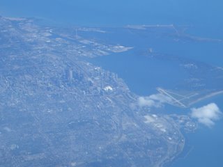
A quick zoom in at the local landmarks. The CN Tower and the Skydome. Great place to go watch the Jays play. For you Cheeker!

This is one of Toronto's many airports, City Centre Airport. We were supposed to start flying in there, but the company cancelled that route. Anyways........

From right over top of Toronto, a look East along Lake Ontario. The scattered line of clouds in the middle is the north shore of the lake.

Waves??????? As we flew under these waves we figured out what had caused them. The image would not capture on film. They are actually vapour trails from a jet that have curled around from the wingtip vortices. Blah, blah pilot jargon. As air slides off an aircraft wing it curls, forming a tornado of sort. This tornado got a hold of the vapour trail and spiralled it around and around. Winglets reduce these wingtip vortices. I thought they were kind of neat to see as I have never seen a vapour trail do this before.


