Monday, August 28, 2006

Bosto-blog

Since the humid part of the summer has come and gone so has the hazy weather. My last few trips to Boston have been crystal clear blue sky. Almost everytime I have flown to Boston our arrival takes us over the city before landing.


A little closer.....4000 feet above sea level. The airport is located at the left edge of the picture in the middle.


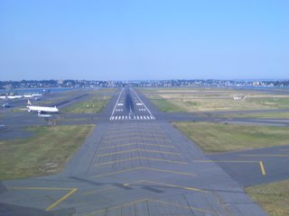
There are 5 runways in Boston Logan airport. Our final approach for runway 4 left takes us over the cargo container shipyard and the harbour. I have yet to snap a photo of another aircraft approaching on the parrallel runway beside me. One day I will!!!!!


It is a busy time of day at Boston with lots of aircraft waiting for departure. I have eyed up a few pieces of oceanfront real estate surrounding the airport. All I am waiting for is to win the lottery.


Short final. There is a Lufthansa A340 ready to go on the left.


This picture I took for all the aviation guru's. I have only spotted one other 757 with winglets and that was in Cleveland. Continental Airlines has a few and apparently American Airlines has some too.

Gaspe....not Gas Bay

The East coast of this country of ours is beautiful. I can only hope that over the next few years I get to see more and more from air and from the ground. I managed to snap a few photos of the coast. I wanted to capture a well known landmark from the Gaspe region. It is a bit hard to see it at the bottom of this photo.


Perce Rock!


This large peninsula is about 20 miles to the East of the airport and we fly over it every time we do a westbound landing.


The Gaspe airport, nestled among the "mountains" of Eastern Quebec. I was asked by a crew member to get out of the aircraft one day to have a smell. A bit wierd at first I thought but you can actually smell the pine trees. The air is so fresh and clean and.........not humid.

Monday, August 14, 2006

The Islands of Magdalen


What a beautiful place!! I had never heard of this place until I moved to Montreal and saw pictures of it in the airport. It is a very popular place for 'Quebecers' to vacation. I have been fortunate enough to go there on clear days. In this picture, we are just about to cross over the largest of the islands in preparation to land.


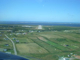
Our view of the runway as we turn on to final approach.


Short final Runway 34. This is Iles de Madeline's shortest runway, at 3600 feet long. This is a very nice approach, turning over the water and crossing farmland to touchdown.


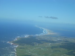
There are miles and miles of beaches here. If it is not a sandy beach it is cliff of sort. Some cliffs are white shale and others are a dark red sand. A large portion of the Northern part of the island is a bird sanctuary.


One portion of the shoreline I walked along was strewn with rusty old machine parts. I believe these were part of a track assembly, upon further inspection. From their condition, I can say they've been here a while.............a long while.


The islands run Southwest to Northeast in the Gulf of St.Lawrence, just above Prince Edward Island. This view is looking Northeast...


...and a look South East...


These are a common sight in Eastern Canada. There are actually wind farms with dozens of these propellers, spread out across the countryside.


Here is an example of the houses in Iles de Madeline . It is almost like being on a movie set, because every house is perfect. The paint is new, the grass is cut perfectly, there is no garbage anywhere and the flower gardens seem perfect. It was a bit creepy actually. One might think they were on a different planet...


I visited a small harbour where, once again, everything was perfect. All the fishing boats were spotless and looked like they just come out of the paintshop.


After all of my sightseeing, I figured it was time to relax on the beach for a bit. Did I mention I was here for work? This is truly a beautiful place. Those looking for a hot day on the beach may be out of luck. It gets warm, but very seldom is it more than 25 degrees and it's often windy. I have been informed that it almost shuts down in early fall, due to the drastic drop in tourism. I am sure it is quite beautiful year round.


A nasty isolated storm on the way home the next day. It has a perfect anvil shape, as the winds of the tropopause push the top over.


A bit of an unusual sight to see two aircraft so close!! Obviously at different altitudes, these two are on their way to Toronto. The race is on!!

Until next time..........

Tuesday, August 08, 2006

The East Coast Adventures


The Mighty St. Lawrence River. I think this photo is taken from about 8000 feet, over Trois Rivieres (halfway from Montreal to Quebec City). At the far end of the picture where the river splits is Quebec City. The whole St. Lawrence flood plain is very flat and covered by farmland. I know the Lower Mainland in BC is flat but at least there are huge mountains on either side. Here there are no mountains.

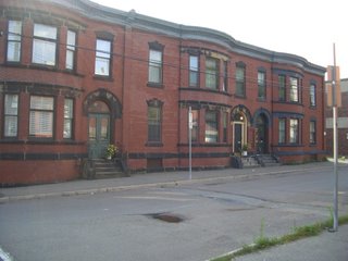
I had the pleasure of spending an afternoon and evening in St. John. I recommend a visit here. This old part of town is quite small and very touristy. I walked around for about 2 hours and saw the better part of the old town. My stay in the city didn't take me to the more modern part of town though. Maybe next time...


An old apartment block.


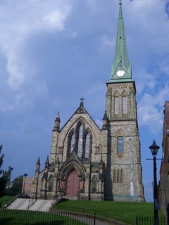
I wonder where the left side of this church went. Maybe it was built this way but it looks......not quite right.


I took this picture because it reminded me of a movie set. It is in the old downtown of St. John NB, but I could have sworn it was a set.


Here, we are in the climb out of St. John in the morning.....It is some bizarre hour.....something in the 5's I think. Really, who wants to travel in a noisy airplane at this ridiculous hour. Beautiful day though and always nice to watch the sunrise in cruise at 24 000 feet with a coffee and an OJ.


I have taken a lot of pictures of this bridge and they never seem to turn out. This day I managed to get a decent shot. The Confederation Bridge is 11 kilometers long. From this altitude it seems only a few inches long. My knowledge of the East Coast is getting better but I believe the bridge goes from New Brunswick to PEI.


This is the metropolis of Charlottetown. I had a visit here 17 years ago. I honestly remembered it as a bigger place but now it seems pretty small...............even for a town where Canada was written in to this world. The city of Summerside west of Charlottetown is a bit larger.


It is a well known fact that flight crew lunches from Quebec city are the best. For a boxed lunch it is pretty good. Today it is artichoke hearts in a vinaigrette dressing, smoked ham and Swiss on ciabattaa, fresh zucchini, red peppers, a slab of cheddar and for a dessert a nutty chocolate cake.


We are not lost...........these are not the cliffs of Dover. This happens to be just outside of Gaspe on the approach to land on Runway 29. There is another very recognizable landmark near Gaspe that I will post another time.


After a gruelling day of work.......2 flights and a ride up to Rouyn Noranda my day was finished at 1300. I spent the afternoon walking around this mining town of about 16 000. This town surrounds Lake Osiska. The lake looks nice on a map but is the farthest thing from it. It is a shame, but the mine and the local hospital have polluted it so much it now smells like a septic tank. Oh well, the town is nice, and apparently the city is working on a long term plan to clean up the lake. This is the restaurant that for some reason, I felt compelled to eat at. Lucky for me, it was quite good.


I have always wanted to name my future dog BOB. How cool is this dog?


The view from my office windows. It is quite annoying when you get a great view like this on a nice day and the windshield is covered with bugs. We have no bug wash to clean it, and the wipers are not effective unless it is really raining hard.


Here it is Co-Captain! This is the Control Tower in Boston. They were a bit reluctant to allow this request. I got as close to the ground as possible. I am sorry, but I was unable to get my passengers reaction on film but I was busy having a sip of my steaming hot double double during this maneuver. Any other requests? That one was pretty easy. Ha Ha!!

Hint for next blog.............Captain Blog does Iles de Madeline.

Monday, August 07, 2006

Bird Strike!!!


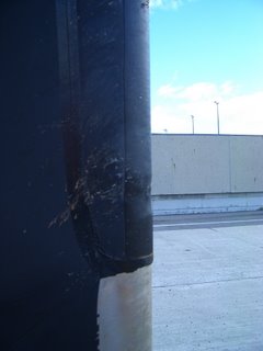
As many people know, birds are a huge problem for airplanes and aiports. Here is an example why. Just as we were taking off out of Gaspe this morning a few seagulls flew right in front of us. We heard a big thump but everything seemed to be ok so we continued on to our destination.


When we arrived we had maintenance do a thorough inspection. He found a dent in one of our propeller blades.

There were also pieces of bone or beak lodged in the rubber edge of the blade. Not so good! These blades are made from carbon fibre. They have a metal front on half of it to prevent wear and a rubber front on the other half which is electrically heated to prevent ice build-up. Each blade weighs about 80 lbs. There turned out to be enough damage to ground the airplane. The blade had to be changed. So after waiting for the part to be flown in, the blade changing process and the ground test, we had a 6 hour wait in the ever-so-exciting Quebec City airport. Time for some poutine I guess.


Almost finished.........just the spinner cap to go on.
More adventures of Captain blog to come soon.

Wednesday, August 02, 2006

Welcome aboard......


Montreal on a clear day, few and far between.

Keep your eyes out in the future for this up and coming Blog of my adventures in aviation. I hope to (for those of you that care) give you a little insight into what goes on. The things I see, the places I go and how I spend my days at the J-O-B.


The endless beaches of Iles de Madeline.

Please feel free to comment and let me know if you have any special requests...ie. Aerial pictures of your house - only if you live out here, special clouds you want to see. You know, boring pilot stuff!! Hook me up to your Favourites and keep your eye out for more Adventures from Captain Blog.


"Let's go around these ones."
If you can believe it, this line of thunder storms was spitting hail out the top at 60,000 feet!